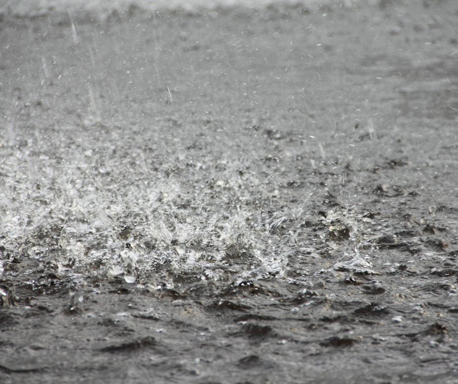
People in Donegal are being warned of severe weather expected in the next few hours, involving flooding and potential lighting strikes.
A yellow weather warning for thunderstorms came into effect at 3 o’clock, and ends at 6pm tomorrow.
Donegal County Council is urging the public to stay safe and if heavy rain begins, avoid unnecessary driving, and under no circumstances drive through floodwaters.
Alan O’Reilly from Carlow Weather says the storms could bring a lot of hail……….
**************************
Warning in full –
Donegal County Council urges public to stay safe during forecast Severe Weather Event
A status Yellow Thunderstorm warning has been issued for Donegal from 3pm Today, Thursday 25th of June until 6pm Friday June 26th with thunderstorms developing today, overnight, and into Friday with the risk of torrential downpours and localised flooding with possible impacts of; localised flooding, lightning damage, hail, hazardous driving conditions and gusty winds.
The main public advice if thunderstorms develop in your area is as follows
- If you hear thunder, move indoors immediately.
- If heavy rain begins, avoid driving unless necessary.
- If roads become flooded, turn around and find another route.
- Never drive, walk or cycle through floodwater. Heavy rainfall can cause dangerous flash flooding with little warning.
- If lightning develops, stop outdoor sports and seek shelter.
Members of the public are encouraged to plan ahead, stay informed of the latest weather updates from met.ie as they develop, and take all practical precautions to protect their safety.
This is a very unpredictable storm front, with forecasts for potentially large and severe hailstorms with hailstones up to 5cm in size, flash flooding from heavy downpours, and severe lightning strikes.
In the event of instances of flooding in urban areas the Council maintains a large stock of pre-filled sandbags at numerous locations across the county and will respond to flooding events should they arise.
Donegal County Council’s Severe Weather Assessment Team met earlier this afternoon and will continue to monitor the evolving weather situation. Council services have been placed on an advanced state of readiness to respond to any emerging situations arising from this weather-related event.
Key Public Safety Messages:
- Driving conditions may be hazardous, please drive with care, and be mindful of other road users, particularly pedestrians and cyclists
- Festival and event organisers are advised to ensure that all temporary structures are safely and securely erected, and to monitor weather updates
- Those camping and caravanning should monitor the forecast and choose sheltered locations and avoid exposed sites on hillsides or cliffs.
- Monitor Met Éireann forecasts and/or visit https://www.met.ie/ for the most up to date information. Information is available across social media platforms and other news media sources.
- ESB Networks is highlighting the dangers posed by fallen live wires and is advising the public and the emergency services to stay away from these fallen cables and to report such cases to it immediately. ESB Emergency Services can be contacted at 1800 372 999. The public can monitor www.PowerCheck.ie for power restoration times.
Donegal County Council is also sharing the following national advice from the National Directorate for Fire & Emergency Management.
National Directorate for Fire & Emergency Management statement on the predicted weather conditions for 25th & 26th June.
The National Severe Weather & Flooding Coordination Group met with key stakeholders this morning to review and prepare for the weather conditions that are predicted for Ireland over the next two days. There are two separate weather-related risks that the public needs to consider over the next 48 hours: the dangers associated with extreme high temperatures and the increased risks associated with heavy thunderstorms.
The recent high temperatures have been welcomed and enjoyed by many people; however, the public is reminded to remain vigilant in relation to the risks associated with high temperatures. Today, it is possible that parts of Ireland will experience record high temperatures, and this presents potential risks. In particular, the public is reminded to keep hydrated, stay out of the sun during the hottest part of the day, avoid strenuous activity and not to leave people and animals unattended in vehicles for any period of time.
Met Éireann has also identified the potential for severe thunderstorms with the possibility of torrential downpours, localised flash flooding, large hail and damaging wind gusts. This risk exists for all of Ireland, but with a higher potential for impacting on the midlands, west and north west this evening and into Friday. The public is therefore encouraged to remain weather aware and be prepared to take action if conditions deteriorate in their area.
Speaking afterwards, the Director of the National Directorate of Fire and Emergency Management (NDFEM), Keith Leonard emphasised;
“There are two separate weather-related risks that the public needs to consider over the next 48 hours: the dangers associated with extreme high temperatures and the increased risks associated with heavy thunderstorms.
Mr Leonard added:
“This risk exists for all of Ireland, but with a higher potential for impacting on the midlands, west and north west this evening and into Friday. The public is therefore encouraged to remain weather aware and be prepared to take action if conditions deteriorate in their area.”
The main public advice if thunderstorms develop in your area is as follows
- If you hear thunder, move indoors immediately.
- If heavy rain begins, avoid driving unless necessary.
- If roads become flooded, turn around and find another route.
- Never drive, walk or cycle through floodwater. Heavy rainfall can cause dangerous flash flooding with little warning.
- If lightning develops, stop outdoor sports and seek shelter.
Forecast Conditions
Met Éireann has indicated that exceptionally warm weather is expected across Ireland for the next two days, with high daytime temperatures, warm and humid nights, and the possibility of thunderstorms.
- Daytime temperatures are expected to exceed 27°C, with values possibly reaching record highs on Thursday.
- Night-time conditions are expected to remain very mild and humid, with temperatures generally staying above 15°C.
- Thunderstorms are possible, particularly on Thursday and Friday. Thunderstorms can produce intense rainfall over a short period. This may lead to sudden surface water flooding, poor visibility and hazardous road conditions, even in areas that do not normally flood.
A yellow weather warning for high temperatures has been issued and remains in place until 09:00 Saturday, 27/06/2026.
The public should continue to check the Met Éireann website www.met.ie and app for the latest forecasts and weather warnings.
Public Health is a significant consideration during high-temperature events, and the public is advised to
- Stay in the shade and be Sunsmart
- Avoid going out or partaking in strenuous activities during the hottest part of the day
- Drink plenty of fluids
- Apply UVA and UVB sunscreen to skin that is not covered, factor 30+ for adults and 50+ for children
- Look out for others who may be impacted by the weather conditions
The high temperatures today and this evening can be a real strain for elderly people. If you know and elderly person who is living alone, call in a check that they are comfortable and have access to cold drinks. A short visit could can make a huge difference to the wellbeing of an elderly neighbour today
The Health Services Executive (HSE) have specific and comprehensive advice on staying safe in hot weather, and this can be accessed at the following address.
Water Safety
The Irish Coast Guard, Water Safety Ireland, Waterways Ireland and the RNLI are urging the public to stay safe and remember that water safety is not just about swimming or water sports. It is relevant to everyday activities such as coastal walks, cycling beside canals, angling, or visiting parks and beaches with family. Drowning data shows that most accidental drownings (65%) follow land-based activities such as walking, angling, cycling, or simply spending time near the water. Now is the time for families and communities to have important conversations about staying safe near water. Awareness is a Lifesaver.
For more water safety information, contact www.watersafety.ie.
- If you’re planning an activity in or on the water, remember:
- Swim at a lifeguarded waterway if possible.
- Swim where you can be seen within your depth and stay within your depth.
- Avoid entering the water in locks, marinas and harbours where hidden hazards may be present.
- Supervise Children: Never leave them unattended near water.
- Avoid Alcohol before swimming, operating watercraft or being near water, as it impairs judgment, coordination, and reaction time.
- Be aware that cold water temperatures can also cause cold water shock, increasing the risk of drowning.
- Pay attention to all water safety signs and warnings and carry a means of calling for help.
- Check tides and updated weather warnings.
- Always wear a correctly fitting serviced lifejacket or buoyancy aid when boating or participating in water sports.
- Let others know where you are going and when you expect to return.
Water Supply
While reservoirs, rivers and groundwater sources recovered earlier this year, that does not guarantee water security for all areas in the months ahead. Water supply continues to face challenges from rising demand and increasingly unpredictable weather patterns. Even where supplies are stable, a period of dry or warm weather can quickly place pressure on some areas. The public is reminded that every individual water-saving action counts, and using only what you need really helps to make a positive contribution that can benefit everyone and avoid water restrictions.
Customers can contact Uisce Éireann’s 24/7 helpdesk at 1800 278 278 or visit https://www.water.ie/
Fire Safety
A High Fire Risk warning has been issued by the Forestry Section of the Department of Agriculture, Food and the Marine. This indicates that the conditions exist for wildfires in all areas where dead grasses and shrub fuels such as heather and gorse exist.
The public is reminded that everybody has a part to play in protecting our unique rural landscapes, communities, habitats and forest resources from the threats posed by wildfire. If you are out and about enjoying our countryside and forests this summer, please help to reduce the risks of fire by keeping the following in mind:
- Do not light fires in or near woodland. Use only designated barbecue points where available. Thoroughly soak BBQ embers after use and make sure that they are extinguished completely.
- Do not block forest entrances or roads when parking – access may be required by the fire service or forestry personnel in the event of an emergency.
- If you see a fire, report it immediately to the emergency services – Dial 999 or 112.
- Report any illegal and suspicious activity to the Gardai. Note that the burning of growing vegetation on uncultivated land between 1 March and 31 August each year is prohibited by law.
- Do not approach fires or attempt to extinguish fires yourself. Wildfires can be extremely dangerous and can rapidly change direction and behaviour.
Further advice is available from the Department of Agriculture, Food and the Marine at https://www.gov.ie/en/department-of-agriculture-food-and-the-marine/publications/fire-management/
With the potential for thunderstorms today people should be mindful of the potential for flooding. Summer flash floods can hit in minutes and are probably the most hazardous type of flooding event. If you come across flooded road while driving, turnaround and find an alternative route. You cannot see how deep the water is and you don’t know of the road surface has been completely washed away. If you need to be rescued from a flood do not hesitate to call 999 for assistenace.
The National Directorate for Fire & Emergency Management (NDFEM) will continue to liaise with all the relevant stakeholders to monitor the weather conditions during this weather event.


